Best Time to Visit Cebu for Clear Blue Water

South Cebu possesses a distinct geological signature that turns its river systems into a brilliant, opaque turquoise. Travelers cross oceans to stand at the edge of the plunging cascades of Inambakan Falls, hoping to capture teh perfect photograph of this otherworldly color. The phenomenon relies heavily on timing, reacting immediately to the whims of the atmosphere. Arrive on the wrong afternoon, and that surreal cyan pool might resemble a churned pot of muddy coffee. The visual transformation is absolute, turning a tranquil jungle oasis into a roaring, turbid force of nature.
Photographers and freedivers constantly chase the optimal window for maximum clarity. You can maximize your chances by booking a comprehensive guided expedition that pairs the gin-clear waters of the Moalboal sardine run with the jungle-draped limestone canyons of Ginatilan. Securing the absolute best conditions requires a fundamental understanding of the Philippine trade winds.
Understanding Philippine Weather: Amihan vs. Habagat
The archipelago operates on two dominant meteorological rhythms. These monsoon seasons dictate the humidity, ambient temperature, and rainfall volume across the Visayas. According to the Philippine Atmospheric, Geophysical and Astronomical Services Administration (PAGASA), the transition between these winds dramatically alters the watershed, dictating whether the rivers flow clear or run thick with mud.
Amihan (The Northeast Monsoon)
Blowing in from Siberia and the Pacific, Amihan dominates from October through March. The air carries a crisp edge during the early months, dropping morning temperatures to comfortable levels for long jungle treks. By the time March rolls around, the climate gradually heats up to the peak summer swelter of April and May. This extended dry period drains excess runoff from the mountains, allowing the rivers to settle and the sediment to sink. The water flow slows down slightly, but the clarity hits its absolute peak. If you want maximum saturation in your waterfall photography, this is the season you want to book your flight for.
Habagat (The Southwest Monsoon)
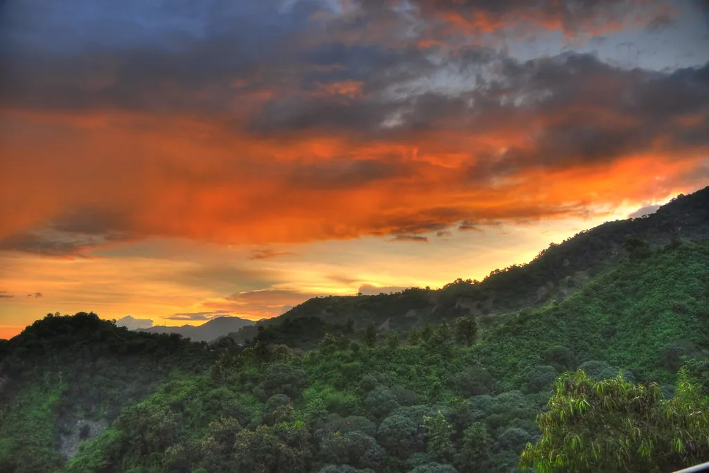
From June through November, Habagat pulls warm, moisture-laden air from the Indian Ocean, sweeping it across the archipelago. Afternoon thunderstorms erupt over the central mountains of Cebu with little warning. Local MDRRMOs (Municipal Disaster Risk Reduction and Management Offices) often issue localized advisories during severe squalls, reminding visitors to stay out of the remote canyons. While the heavy cloud cover drops the blistering ambient temperature, the sudden influx of rainwater drastically changes the physical landscape of the river systems. A clear morning can rapidly devolve into a torrential afternoon washout.
The Science Behind the Blue and the Brown Water Phenomenon
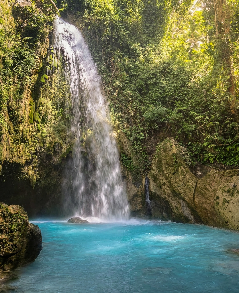
The secret to the glowing water lies beneath the forest floor. South Cebu rests on a massive bed of porous, ancient limestone. As rainwater filters slowly through the rock over months and years, it absorbs high concentrations of calcium carbonate. When this mineral-rich groundwater finally surges out of the springs into the open air and intense tropical sunlight hits the suspended microscopic particles, the blue spectrum of light scatters. The result is an intensely bright, milky blue that defines the multi-level cascades of Inambakan. The calcium coats the rocks in a rough, grippy texture, making the limestone surprisingly easy to climb despite the constant flow of water.
The Gatorade-blue color is a delicate chemical illusion—one that a single heavy downpour can erase in minutes.
That mesmerizing illusion shatters when Habagat dumps torrential rain onto the highlands. The sun-baked ground cannot absorb the sudden deluge. Surface runoff bypasses the natural limestone filtration system entirely, sweeping topsoil, decaying leaves, and loose sediment directly into the watershed. Within an hour of a heavy storm in the upper mountains, the iconic blue vanishes, replaced by a churning, opaque brown. Water visibility drops to zero, and the kinetic energy of the current accelerates to dangerous speeds, capable of dragging large debris through the narrow canyons.
During these flash flood scenarios, local authorities suspend swimming activities immediately. Always consult the Visitor Rules & Guidelines and speak with your local guide before entering the water. If a morning storm washes out your river trek, you can pivot to nearby coastal attractions or a coastal snorkeling journey, as the massive volume of the ocean diffuses the silt runoff far faster than the inland rivers clear their channels.
Local Tip: Habal-habal drivers in Ginatilan town proper know the mountain weather better than any smartphone application. Always ask them about the upper river conditions before paying your entrance fees.
Month-by-Month Water Clarity Breakdown
Timing your arrival dictates your entire experience. To help you plan your visit, cross-reference your travel dates with this historical clarity index.
| Month | Weather Pattern | Water Clarity | Volume & Flow |
|---|---|---|---|
| December – February | Peak Amihan (Cool/Dry) | Very High | Strong and steady |
| March – May | Peak Summer (Hot/Dry) | Absolute Peak (Crystal Blue) | Moderate to low |
| June – July | Transition to Habagat | Variable (Hit or Miss) | Increasing rapidly |
| August – November | Peak Habagat (Wet/Typhoons) | Low (High risk of brown runoff) | Torrential |
Deep Dive: The Seasonal Shifts
- The Golden Window (March to May): The hottest months in the Philippines yield the most reliable conditions for waterfall chasing. Rain is exceptionally rare, meaning the rivers run clear nearly every single day. You will face heavier crowds and intense midday heat on the trails, but the visual reward of the perfectly still, cyan pools is unparalleled.
- The Sweet Spot (December to February): The transition out of typhoon season leaves the rivers swollen and powerful, yet clear. The Amihan winds keep the humidity manageable. This is arguably the most comfortable time for the steep, technical hikes required to access the upper falls.
- The Roll of the Dice (June and November): These transitional months can go either way. You might experience a full week of brilliant sunshine, or you might sit through consecutive days of gray skies and scattered showers. Flexibility is mandatory if you travel during this window.
- The High Risk Zone (July to October): Deep into the monsoon season, typhoons frequently scrape past the Visayas. Even if a storm does not hit Cebu directly, the peripheral rain bands will saturate the mountains. Rivers frequently run brown during these months, and trail closures happen often.
South Cebu Watershed and Terrain Context
Understanding the topography of Ginatilan and its neighboring municipalities explains why some waterfalls remain clear while others muddy quickly. The rivers originate deep in the central spine of the island, catching heavy rain that falls on the high peaks. According to conservation reports from the Cebu Provincial Government, the dense forest cover in the upper elevations slows the runoff, but human encroachment and steep agricultural slopes accelerate soil erosion during heavy rains. The health of the entire watershed directly dictates the color of the water downstream.
Travelers crossing this terrain must stay adaptable. Reviewing how to get to Inambakan Falls prepares you for the rural road conditions, which can degrade into slick mud after localized storms. The conservation and environment efforts led by the local barangays aim to stabilize these vulnerable riverbanks through targeted reforestation. When you visit during the dry season, you witness the watershed in its most pristine, balanced state—a brilliant slash of blue cutting through the emerald green canopy.
By packing your schedule with inland waterfall hikes during the dry season and reserving the wet season for deep-water oceanic activities, you align your itinerary with the natural rhythms of the island. To maximize your time in the region, consider mapping out a comprehensive South Cebu 3-Day Itinerary. By clustering your river treks during the predictably clear morning hours and saving coastal transit for the unpredictable afternoons, you stack the odds entirely in your favor.