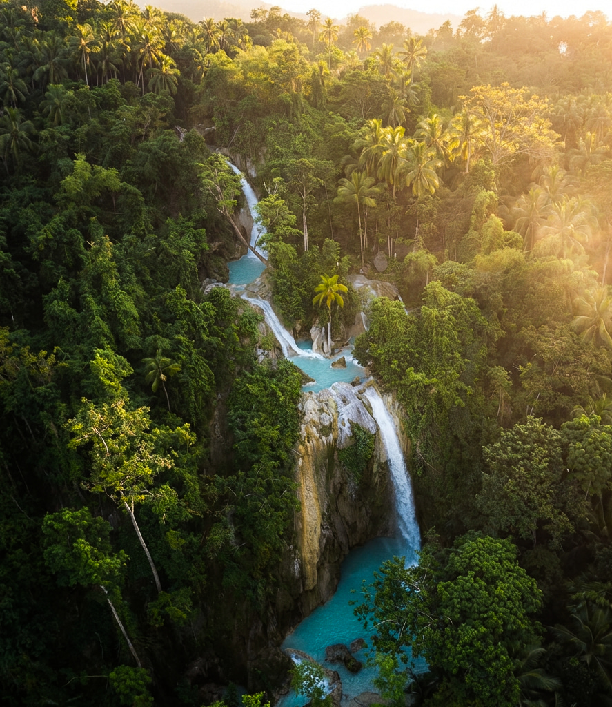
Most travelers picture Inambakan Falls as a singular, thunderous drop. The reality stretches far beyond that initial plunge. Carved over millennia by the relentless water of the Ginatilan Watershed, this destination unfolds as a complex five-level cascade system. Protected by local community cooperatives and monitored by the Department of Environment and Natural Resources (DENR), the dense jungle corridor climbing up the mountain demands exploration. Stopping at the main pool means reading only the first chapter of a much larger geological narrative.
“To stop at the main pool is to abandon the journey halfway. The upper cascades reveal the raw, undisturbed beauty of South Cebu’s limestone geology.”
The intricate canyon formations and opaque turquoise pools demonstrate classic karst topography. This landscape is heavily fractured by dissolved limestone, a geological feature recognized extensively by the Mines and Geosciences Bureau (MGB). Rainwater filters through the porous rock of the surrounding mountains, gathering minerals before bursting from underground springs. Climbing higher shifts the terrain dramatically. Paved steps give way to wild river wading, challenging your balance while rewarding you with solitude.
Understanding the layout prevents you from missing the best sections. You need to pace yourself, manage your energy, and appreciate the subtle changes in the environment as you ascend. We structured this guide to break down exactly what awaits at every altitude.
Level 1: The Majestic Main Cascade
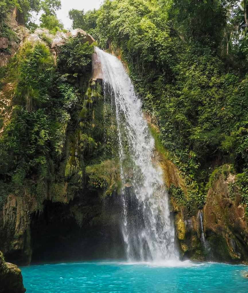
Level 1 anchors the entire experience. A sheer 30-meter vertical wall dominates the space, dropping heavy volumes of water into a wide, milky-blue basin. The sheer force generates a perpetual mist, cooling the surrounding canyon walls and clinging to the giant ferns overhead. The roar of the water echoing off the rock faces makes conversation difficult, forcing you to simply absorb the scale of the environment.
Strong swimmers often cross the wide basin to discover a shallow cavern situated directly behind the waterfall’s heavy veil. Standing inside this limestone recess, you look out through a roaring curtain of water—a surreal perspective of the jungle beyond. Life vests are heavily regulated for this deep section. Review our Tickets & Tours page to check entrance inclusions and safety gear requirements before you arrive.
Many international visitors choose to bundle this massive lower tier into a broader comprehensive South Cebu day tour that handles all the complex driving logistics. If you decide to go it alone, Level 1 serves as your staging ground. You leave your heavy bags here with a local caretaker before beginning the upward scramble.
Levels 2 & 3: Bugnawan & Kampael
Leaving the crowds behind, the trail ascends sharply toward Level 2. Locals call this tier Bugnawan Falls, deriving the name from the Cebuano word for cold. No concrete platforms exist here. You scramble up a steep dirt incline to find a narrow chute rushing through raw, fern-covered cliffs. It feels isolated, stripping away any commercialized veneer. The water temperature drops noticeably, shielded entirely from the morning sun by the towering gorge.
Just above Bugnawan lies Level 3, Kampael Falls. Adrenaline seekers congregate at this mid-level hub. Nature carved distinct, stair-like footholds into the rock face, framing a deep, perfectly clear catching pool. It serves as a natural cliff-jumping arena. The setup aligns perfectly with the eco-adventure standards promoted by the Philippines Department of Tourism (DOT), maintaining safety without altering the landscape.
The water depth fluctuates between 8 to 12 feet depending on recent rains, absorbing high-impact leaps with ease. You step to the edge, gauge the distance, and let gravity do the rest. This is the exact kind of raw environment you want to be a part of.
- Target Audience: Thrill-seekers and confident swimmers.
- Water Depth: Approximately 8-12 feet (varies by wet/dry season).
- Atmosphere: Active, adventurous, and distinctly secluded.
Levels 4 & 5: The Enchanted Forest
The uppermost reaches of the Inambakan system reward persistent hikers with pure tranquility. Level 4 flattens out into shallower, cascading rapids. Centuries of water friction smoothed the bedrock into natural water slides. You can sit directly in the current, letting the water rush past while sunlight pierces the dense canopy above. It presents a stark contrast to the sheer vertical drops below.
The grand finale at Level 5 feels distinctly prehistoric. A final four-meter drop pours into an emerald-green natural swimming hole, heavily shaded by overarching, cave-like limestone formations. Preserving this pristine environment relies heavily on visitors practicing strict Leave No Trace principles. Bring a snorkel. The water clarity up here outshines the lower basins, revealing freshwater fish darting among the submerged rocks.
Learn more about our regional preservation efforts on our Conservation & Environment page. If you are stringing together multiple destinations, the quiet isolation of this peak contrasts perfectly with the intense, chaotic energy of a guided canyoneering adventure at Kawasan.
“Level 5 is Ginatilan’s best-kept secret. By the time most people reach Kampael, they turn back. Pushing those last ten minutes upward changes the entire trip.”
— Local Guide, Ginatilan Tourism Cooperative
Color Contrasts: Milky Blue to Translucent Blue
A fascinating geological phenomenon occurs as you hike the river system. The visual shift in water color is staggering. At Level 1, the water mimics a milky blue sports drink. This opacity comes from suspended calcium carbonate particles originating from dissolved limestone higher up the mountain. The sheer turbulence of the 100-foot drop keeps these particles entirely mixed into the water column.
As you climb toward the source, the turbulence decreases. The suspended minerals settle against the riverbed. By the time you reach Level 5, the water becomes a crystal-clear, translucent blue. The white rock base reflects the sunlight back up through the canopy cover, creating a glowing effect beneath the surface. Understanding this transition adds a massive layer of appreciation to the hike. You are watching a natural filtration system operate in real-time.
Navigating the Tiers: Why a Guide is Highly Recommended
While the path to the main basin is obvious, the upper trail involves steep steps and rocky terrain. Although not mandatory, hiring a local guide from the Ginatilan municipality secures your safety and supports the local economy. These young men and women know every submerged rock and slick root. They test the jump depths daily, adjusting their advice based on overnight rainfall.
Beyond safety, they act as exceptional trail photographers. They know exactly how to handle a smartphone to capture the scale of Level 1 or the intimate lighting of Level 4. Tipping your guide generously acknowledges the physical effort they exert hauling dry bags and tracking your footing across wet limestone. You can read more about local etiquette and expectations on our Visitor Rules & Guidelines page.
The Ascent: Trail Conditions & Terrain
Conquering the multi-level cascade demands physical engagement. Expect a combination of steep dirt paths, minor rock scrambling, bamboo bridges, and literal river wading. Proper footwear dictates your success on this trail.
| Cascade Level | Trail Difficulty | Estimated Hike Time (from previous level) |
|---|---|---|
| Level 1 (Main Drop) | Easy (Paved Stairs) | 10 Minutes from Entrance |
| Level 2 (Bugnawan) | Moderate (Steep Dirt Incline) | 15 Minutes |
| Level 3 (Kampael) | Moderate (Root Steps) | 5 Minutes |
| Level 4 (Tipolo) | Hard (River Wading) | 15 Minutes |
| Level 5 (Inabutan) | Hard (Rock Scrambling) | 10 Minutes |
Pro Tips for the Multi-Level Trek
- Footwear: Wear aquatic shoes or trekking sandals with aggressive rubber grip. Flip-flops fail instantly on wet limestone and mud.
- Hydration: Carry a reusable water bottle. Vendors operate strictly at the main entrance, leaving the upper trails completely unserviced.
- Timing: Start your ascent early—around 7:30 AM. Beating the midday heat guarantees you experience the upper levels in complete solitude before the crowds arrive.
- Preparation: Cross-reference our Plan Your Visit guide for comprehensive packing lists. Understanding the seasonal weather shifts helps you gauge water levels across the different tiers.
- Regional Context: Expanding your trip requires reliable transit knowledge. Check our transportation guide for local bus routes, or dive into our South Cebu 3-Day Itinerary to map out your next move toward neighboring attractions.
For those intent on maximizing their time in the province, combining this demanding trek with coastal activities creates the ultimate itinerary. Many travelers follow their jungle ascent with a coastal snorkeling tour in Moalboal, trading fresh water for salt water as the afternoon peaks. Regardless of your next stop, standing at the summit of Level 5 earns you a quiet sense of accomplishment that the paved pathways of other tourist traps simply cannot match.