Introduction: Inambakan Falls as Your Gateway to the Cebu Tourist Circuit
The southern stretch of Cebu demands more than a fleeting day trip. Setting your base camp near the striking blue tiers of Inambakan Falls positions you near the southern tip of an island renowned for extreme topography and dense jungle watersheds. You map out a route that trades concrete highways for dirt trails and limestone riverbeds. Instead of rushing back to the city before dusk, staying in the Ginatilan municipality opens up a massive playground of natural wonders scattered across neighboring towns. Travelers who treat the south as a mere checklist completely miss the raw intensity of the landscape. When you use Ginatilan as your launchpad, you cut hours of transit time out of your morning routine. You wake up, grab a quick coffee from a roadside carenderia, and head straight into the mountains before the commercial tour buses even leave the city limits. This regional guide breaks down the essential circuits—from high-altitude peaks to deep marine encounters—that surround your basecamp.South Cebu Waterfall Hopping: Samboan’s Treasures
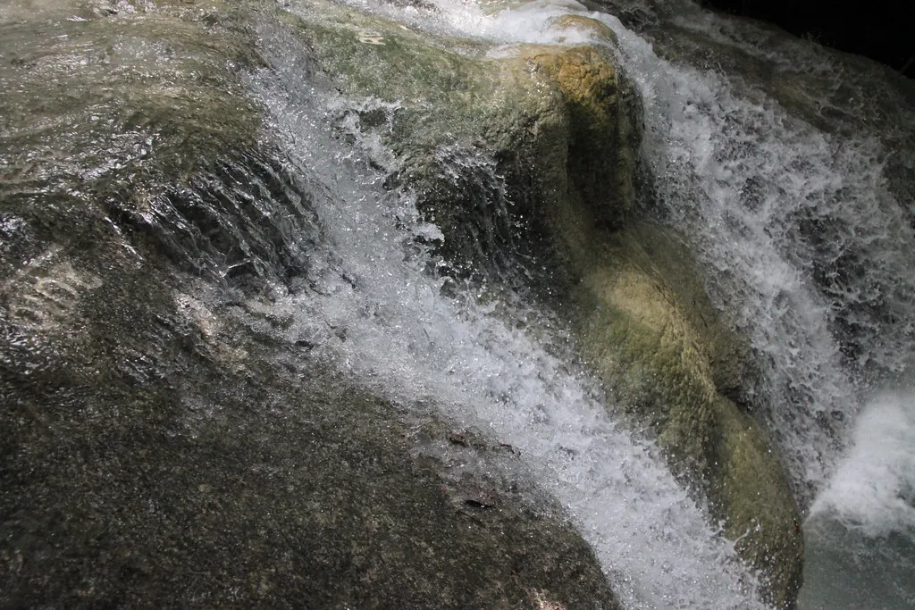
Aguinid Falls forces you to rethink the concept of a hiking trail. The water itself acts as the path—you scramble directly up the limestone face of the cascade using fixed ropes and footholds carved by years of continuous water flow. Local guides trace the safest routes up the five distinct tiers, helping you lock in a solid grip against the heavy current. The calcium-rich water coats the rocks, leaving them surprisingly textured rather than slippery. Reaching the upper levels of Aguinid reveals quiet plunge pools completely shielded by thick jungle canopy. You drop your waterproof bag on the rocks and slide into the cold water to lower your core temperature after the intense upward climb. It serves as an aggressive, intensely physical introduction to the local terrain that sets a high bar for the rest of your itinerary. Securing a spot on a comprehensive waterfall hopping and marine tour streamlines the transition between these neighboring Samboan drops. Dau Falls commands a totally different kind of physical toll. The approach requires a long, humid trek through a rocky riverbed flanked by towering bamboo groves and sheer canyon walls. The river narrows significantly as you push further into the Samboan interior, forcing you to wade chest-deep through emerald water before the main drop finally comes into view. As the tallest waterfall in the municipality, Dau generates a powerful localized wind from the sheer force of water slamming into the basin below. Standing near the impact zone completely drenches your clothes in seconds. The isolation here feels absolute—far removed from the heavy crowds found closer to the provincial highway. For those mapping out their entire week, our planning guide breaks down the specific dry-bag requirements for these deep-water treks.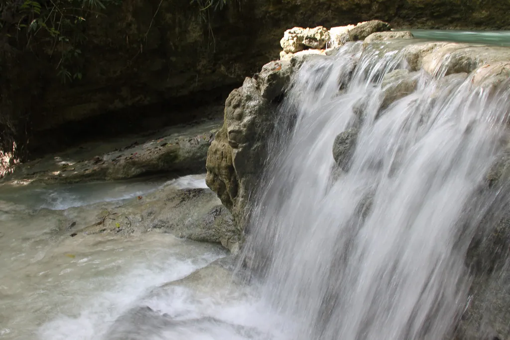
The Adrenaline Rush: Kawasan Falls & Badian Canyoneering
Kawasan Falls defines the international image of Cebu tourism with its opaque turquoise water and massive vertical drops. Most visitors do not just walk to the main pool (which requires a 200 PHP entrance fee); they arrive via a high-impact downstream canyoneering route starting high up in the Badian mountains (the extended Alegria route is suspended as of 2026). You jump off cliffs ranging from ten to thirty feet, slide headfirst down natural rock flumes, and swim through tight slot canyons. The dense concentration of extreme drops makes this the ultimate playground for adrenaline seekers. You can easily book a Kawasan Falls Canyoneering adventure for the government-regulated rate of 1,500 PHP to handle the complex logistics of helmets, life vests, and point-to-point transport up the mountain. Exiting the canyon drops you directly into the main Kawasan basin, where you finally rest on bamboo rafts (available for 300 PHP) floating across the striking blue water. Open daily from 6:00 AM to 5:00 PM, the sheer scale of the operation here contrasts sharply with the quiet, multi-level exploration detailed in our Inambakan levels guide.Majestic Marine Life: Whale Shark Encounters in Oslob
The coastal barangay of Tan-awan in Oslob completely transformed its local economy by regulating interactions with the largest fish in the ocean. Morning routines here involve pushing small wooden outrigger boats just past the surf break, where massive whale sharks cruise just below the surface. You slide off the edge of the hull and immediately lock eyes with creatures the size of city buses. Strict municipal guidelines dictate exactly how these encounters operate to minimize environmental stress. Wardens enforce a strict no-touch policy and ban all chemical sunscreens in the water. For travelers operating on a tight schedule, integrating this morning dive into a wider Oslob Whale Shark Swimming and Canyoneering package maximizes your daylight hours across the southern tip of the island.You slide off the edge of the hull and immediately lock eyes with creatures the size of city buses—a surreal, grounding moment in the warm waters of the Bohol Strait.
Coastal Heritage and History: Exploring Boljoon Church
The Nuestra Señora del Patrocinio de Maria Parish Church stands as a massive coral-stone fortress facing the Bohol Strait. Constructed in the 18th century by Augustinian friars, the structure served a dual purpose: a place of worship and a fortified watchtower guarding against maritime raids. The thick, weathered walls and original terracotta roof tiles immediately ground you in the colonial history of the island. Inside, the ceiling features intricate, century-old paintings that have survived typhoons and earthquakes. The UNESCO Tentative List recognized this specific church for its exceptional Baroque architecture and historical preservation. Walking through the quiet courtyard delivers a necessary mental reset after days spent jumping off cliffs and swimming against heavy river currents.Hidden Cascades of the Southeast: Unwinding at Dayhag Falls
Dayhag Falls cuts through the quiet highlands of Boljoon, far from the main tourist corridor running along the western coast. The water drops over a series of wide, shallow limestone steps, creating dozens of small, personal pools rather than one massive basin. The surrounding forest remains largely untouched, with thick vines and ferns crowding the edge of the water. The lack of deep water makes this particular spot highly appealing for those seeking a slow, restorative afternoon. You sit directly on the smooth rock formations and let the gentle cascade massage your shoulders. It presents a peaceful, low-impact alternative that contrasts sharply with the extreme verticality found at other locations in our South Cebu 3-Day Itinerary.Conquering South Cebu’s Peaks: The Kandungaw Peak Trek
Kandungaw Peak dominates the skyline above Badian with its sheer limestone drop-offs and aggressive elevation gain. The trail forces a steep, continuous upward grind through dense brush before suddenly breaking out onto a narrow, exposed ridge. The wind rips across the summit, dropping the ambient temperature significantly compared to the humid coastal plains below. Standing at the edge of the vertical cliff face reveals an unobstructed view of the western coastline and the neighboring island of Negros. The raw, jagged nature of the summit commands respect and careful foot placement. It draws serious mountaineers and hikers looking to push their physical limits after exhausting the lowland water circuits.
The “Chocolate Hills” of Cebu: Hiking Casino Peak
The highland barangays of Dalaguete earn their reputation as the vegetable basket of Cebu, characterized by cool air and endless rows of hillside crops. Casino Peak rises above these farming communities, showcasing a bizarre geological formation of clustered, conical mounds. The jagged limestone spikes protruding from the grass mirror the famous landscape of neighboring Bohol. Scrambling up the final loose rock section to the peak requires intense focus and steady balance. The reward is a panoramic, 360-degree sweep of the rippling green hills fading into the coastal fog. Finding the exact trailhead can be tricky, so many travelers factor this climb into a broader transport strategy discussed in our public transit guide.Central Cebu Sunset Hikes: The Grassy Slopes of Mt. Naupa
Mount Naupa sits right on the border of Naga City and Minglanilla, pulling hikers away from the extreme south and into the central island topography. The trail climbs through open, rolling grasslands that catch the late afternoon light perfectly. It lacks the brutal vertical drops of the southern ranges, making it an ideal target for a fast-paced sunset ascent. The conical peak itself feels almost perfectly symmetrical, covered in short, wind-swept cogon grass. As the sun dips below the horizon, the sky turns violent shades of purple and orange, casting long shadows across the central valleys. You pack your headlamp for the dark descent back to the city limits, completely satisfied with the short but rewarding trek.Northern Mountain Excursions: Sweeping Vistas at Mt. Mago
Mount Mago holds a unique geographical distinction by straddling the exact boundary lines of two municipalities and a city: Danao City, Carmen, and Tuburan. The hike crosses expansive, open pastures where local cattle graze freely against the backdrop of the rugged northern interior. The terrain rolls endlessly outward, trading the dense jungle of the south for wide-open, breathable space. Reaching the summit marker means you are technically standing in three jurisdictions simultaneously. The sweeping vistas highlight the sheer scale of the island, proving that Cebu holds immense natural value far beyond its famous coastal reefs. The steady, moderate incline makes it a favorite conditioning hike for local mountaineering clubs preparing for larger national expeditions.Venturing Off the Beaten Path: The Remote Carnaza Island
Carnaza Island floats off the extreme northern tip of Cebu, demanding a rough, two-hour boat passage from Tapilon Port (typically ₱200-₱300) across open ocean channels. The island takes the shape of a massive sea turtle, ringed by completely unspoiled coves, blindingly white sand, and dense mangrove forests. The isolation here is absolute—electricity runs on a strict evening schedule and mobile signals vanish almost entirely. You spend your days hiking across the rolling hills that dominate the interior or diving into the pristine water at Skull Cove. With limited commercial development, visitors typically stay in the iconic wooden tents at Carnaza Eco Park (around ₱200 entrance fee) or local homestays, often relying on small eateries or the daily catch pulled straight from the surrounding reef. It requires intense commitment to reach, but delivers the exact sort of adventure you are looking for.Secluded Lagoons & Limestone Cliffs: Discovering Kinatarcan Island
Kinatarcan Island sits quietly near the more heavily trafficked Bantayan Island, yet it remains completely off the standard tourist radar. The coastline features aggressive limestone cliffs that plunge straight into deep, dark blue water, hiding extensive cave systems carved by centuries of tidal action. Exploring the perimeter by outrigger boat reveals massive sinkholes and hidden beach pockets inaccessible by land. Laaw Lagoon serves as the undisputed highlight of the island, an emerald-green pool trapped entirely within high rock walls. You hike through a dense thicket of coastal vegetation to reach the water, which stays perfectly still despite the crashing ocean waves just hundreds of feet away. Note that an entrance fee of around 50 PHP is required, and swimming is typically prohibited to protect the local latô (seaweed) farms. Furthermore, the island no longer appeals strictly to extreme explorers willing to rough it; eco-tourism developments like the Kinatarcan Wellness Resort now offer air-conditioned accommodations and glamping tents for a more comfortable stay.Logistics & Basecamps: Where to Stay When Exploring South Cebu
Selecting the right basecamp dramatically impacts your ability to execute a multi-day itinerary. Towns like Moalboal and Badian dominate the western coast, packed with dive resorts, hostels, and immediate access to transport hubs. Setting up your accommodation in these areas means you can strike out early and beat the heavy crowds at the major waterfalls. Further south, quiet municipalities like Ginatilan and Samboan feature smaller, family-run guesthouses that put you right at the trailhead of the deep jungle treks. The Department of Tourism actively promotes these southern coastal towns as emerging eco-tourism hubs. You trade high-speed internet for empty beaches and immediate access to the towering limestone canyons.Western Coast (Moalboal/Badian)
- High concentration of dining options.
- Immediate access to Kawasan and Sardine Runs.
- Heavier tourist traffic and nightlife.
Deep South (Ginatilan/Samboan)
- Walking distance to Inambakan and Aguinid.
- Highly authentic, quiet village atmosphere.
- Limited evening dining; prepare meals early.
Getting Around: Navigating Between Regional Attractions
The yellow Ceres Liner buses dictate the rhythm of movement across the entire island. They run continuously from the Cebu South Bus Terminal, grinding their way down the coastal highway and dropping passengers at seemingly random dirt intersections. You flag them down by standing on the shoulder of the road and waving aggressively as they approach at high speed. The Department of Public Works and Highways (DPWH) maintains these main arterial roads, ensuring a relatively smooth ride until you veer off toward the mountains. Once you step off the bus, the local habal-habal (motorcycle taxi) drivers take over the final miles. You negotiate a rate, strap on a helmet, and hold tight as the driver leans hard into the steep, winding mountain roads leading to the trailheads. For a granular breakdown of fares and expected transit times, consult our dedicated transport logistics page before you leave the city limits.Always carry small bills—20 and 50 peso notes—when riding habal-habals. Drivers rarely carry exact change for large bills early in the morning.
| Route (From Ginatilan) | Primary Transport Method | Estimated Travel Time |
|---|---|---|
| To Samboan (Aguinid/Dau) | Ceres Bus or Tricycle | 15 – 20 Minutes |
| To Badian (Kawasan Falls) | Ceres Bus | 45 – 60 Minutes |
| To Oslob (Whale Sharks) | Bus to Bato Terminal, then transfer | 1.5 Hours |
| To Dalaguete (Casino Peak) | Bus to Bato Terminal, then transfer, then Habal-Habal | 2.5 Hours |